 |
Daily
CO Column Maps and Movies for the World and for North America
June 1, 2002 through October 31, 2002 |
 |
|
Daily
CO Column Maps and Movies for the World and for North America
June 1, 2002 through October 31, 2002 |
|
Global Map & Movie | N. America Map & Movie | SCIAMACHY & GEOS-CHEM | Why CO? | Groups involved
GEOS-CHEM simulations using the GEOS-3 assimilated meteorological observations from NASA's Data Assimilation Office
These products will support SCIAMACHY retrievals (coming soon!)
NOTE: The GEOS-CHEM model simulations end on October 31, 2002, since this is the last day for which DAO's GEOS-3 assimilated data product is available. In the future we may resume producing daily CO maps using the next-generation GEOS-4/fvDAS meteorological data product.
Global Map
View movie starting from: 1 Jun 2002 | 1 Jul 2002 | 1 Aug 2002 | 1 Sep 2002 | 1 Oct 2002
View CO column maps from previous days
North American Map (INTEX-NA domain)
View movie starting from: 1 Jun 2002 | 1 Jul 2002 | 1 Aug 2002 | 1 Sep 2002 | 1 Oct 2002
View CO column maps from previous days
SCIAMACHY & GEOS-CHEM
SCIAMACHY (SCanning Imaging Absorption SpectroMeter for Atmospheric CHartographY) is a nadir-viewing UV/Vis solar backscatter instrument onboard the European Envisat Satellite platform which was launched on board an Ariane 5 from Kourou, French Guiana, on 1st March 2002, 1:07:57 UT. The satellite is in a sun-synchronous orbit, crossing the equator at about 10 AM local solar time (LT) in the descending node. Among many other atmospheric trace species, SCIAMACHY measures columns of carbon monoxide (CO).
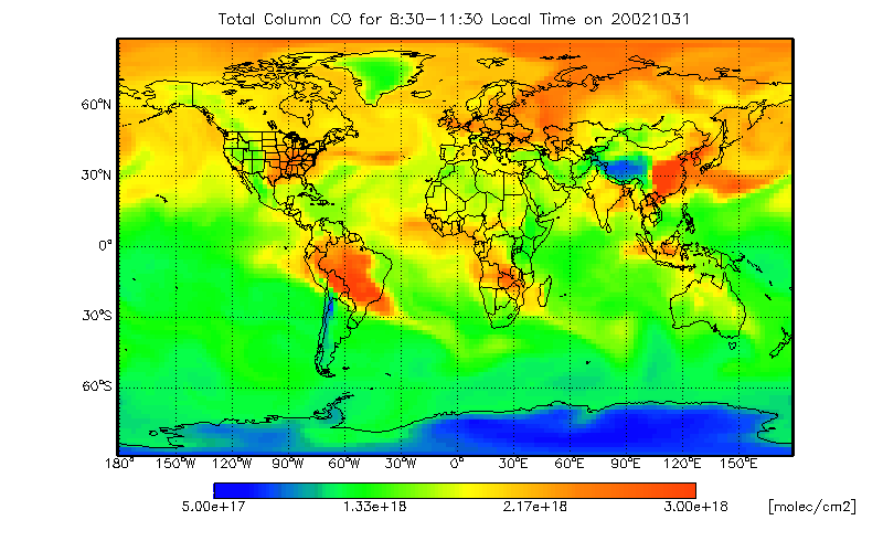
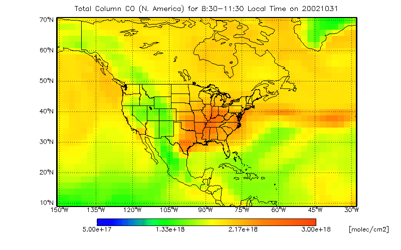
The figures above show the total columns of CO (global and N. America closeup) from the GEOS-CHEM model of tropospheric chemistry, averaged between 8:30-11:30 Local Time. SCIAMACHY will view Earth's atmosphere in a similar manner. We will use the model to interpret the space-based column measurements from SCIAMACHY to better understand source distributions of CO. We expect to obtain SCIAMACHY CO column data starting in July 2002, assuming that all continues to go well onboard Envisat.
NASA's Data Assimilation Office is currently providing the daily assimilated meteorological fields which are needed to drive the GEOS-CHEM model. The operational data product is GEOS-3, which has a native resolution of 1o lat x 1o lon and 48 vertical layers. For computational expediency, we run GEOS-CHEM on a reduced grid, with a horizontal resolution of 2o lat x 2.5o lon, and a vertical resolution of 30 layers.
Why are we interested in CO?
Carbon monoxide is a product of incomplete combustion and is also produced within the atmosphere by oxidation of volatile organic compounds. It is the primary sink of the hydroxyl radical (OH), the main tropospheric oxidant, and as such plays a critical role in determining the oxidising capacity of the atmosphere, and hence the atmospheric lifetimes of environmentally important gases. Carbon monoxide also affects indirectly global warming through the production of O3 and CO2. The lifetime of CO varies as a function of season and latitude; lifetimes are largest (several months) typically at high latitudes during the winter season, and shortest (~one month) at low latitudes during the summer season, reflecting high values of solar zenith angle and the high abundance of water vapor. Because of its relatively long lifetime, CO can be transported for long distances and therefore impact regions far away from its source origin.
Groups Involved:
Harvard University Atmospheric Chemistry Modeling Group
Smithsonian Astrophysical Observatory
NASA's Data Assimilation Office
This web page is maintained by Bob Yantosca (bmy@io.harvard.edu)
